Latest Articles

Saturday, 15 December 2012

North Jakarta City


In accordance with PERDA 6, 1999, North Jakarta area has a Policy and Strategy Development to prioritize the direction of the development of the corridor east, west, north and restricting development to the south in order to achieve the balance of the ecosystem.

According to the above it can be said that the Planning Region is part of the town hall in North Jakarta Municipality that has direction as the development of coastal and marine tourism city. 

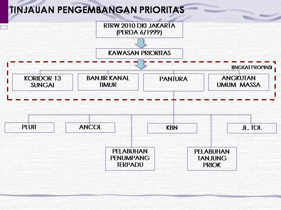
Development activities are prioritized and quite influential in the planning area is

 Development of the port considering the planning area through the direct access Jl. Toll Sedyatmo leading to the port area of ​​Tanjung Priok and development plans waters and islands in the Thousand Islands, which means there is also the development of passenger and fishing port located on Cilincing District (Port of Muara Angke)
 Development of selective industry with more emphasis on the eastern part of North Jakarta Municipality.
 Development of the North Coast region (north coast) as the international scale integrated commercial hub in the future.

And according to the physical characteristics and the development of North Jakarta Municipality including the Northern Development Area consisting of:

1. WP Thousand Islands (WP-KS), a development policy which is mainly aimed at the restoration of tourism, quality of life through improved fishing and aquaculture fisheries resource use with conservation of coral reef ecosystems and forests mengrove

2. North Shore WP (WP-PU) with the policy include:
a) Long Beach:
    1) Promote and preserve the quality of the environment in North Jakarta;
    2) Maintaining a fishing settlement;
    3) Develop and commercial port functions.
b) New Coast: through the development of reclamation that is physically separated from long beach to key services and an international trade, housing, ports and tourism.


read more

District Tanjung Priok , North Jakarta City


Sub Area of ​​Tanjung Priok amounted to 2480 hectares. The use of land in the District of Tanjung Priok in 1995 was dominated by the guesthouse and its facilities with an area 985.92 ha (39.72%). Another is the use of dominant channel / clan with an area 550.92 ha (22.21%) and in 2000 the house and its facilities continued to dominate the land use district of Tanjung Priok this.

Most of the land use in the district of Tanjung Priok is to achieve broad housing 1.286.68 hectares or 51.87% of the entire district in 1995. In Tanjung Priok district, residential areas dominate this district.

Based on the structure of the building housing situation in the District of Tanjung Priok can be grouped into: Permanent, Semi-Permanent and Temporary.
Based on the results of the field survey, the nature of the building in this area  is :
• Permanent Buildings:  45.71% generally found in urban Sunter Agung
• Semi Permanent Building:  32.07% generally found in urban and Warakas Papango
• Temporary Buildings:  22.22% generally found in urban Tanjung Priok.


read more

District Penjaringan , North Jakarta City


District Penjaringan included in North Jakarta. 

Broad Penjaringan district is ± 3549 ha, which means occupying 23.01% of the total floor area of ​​North Jakarta (15 211 ha in 1995 and 15,411 in 2010). 

In the Jakarta Spatial Plan in 2010, the position and role of North Jakarta is very important that as:
a) Port Activity Center with scale national service, even Ocean Regional / international, the port of Tanjung Priok
b) Industrial Activity Center a large scale and are, among others in the Village Cilincing, Marunda and others.
c) Warehousing Activity Center, both warehousing to support the industry and warehousing to support the port.
d) Bus / Sentra primer (Trade and Services) in the north in addition to other primary centers that exist in the Territory of Jakarta.


read more

District Pademangan , North Jakarta City


District Pademangan included in North Jakarta. 

Area of ​​District Pademangan is ± 1.191.87 Ha, which means occupying 7.73% of the total floor area of ​​North Jakarta (15 211 ha in 1995 and 15,411 in 2010).

In the Jakarta Spatial Plan in 2010, the position and role of North Jakarta is very important that as:
a) Port Activity Center with scale national service, even Ocean Regional / international, by Cilincing port.
b) Industrial Activity Center a large scale and are, among others in the Village Cilincing, Marunda and others.
c) Warehousing Activity Center, both warehousing to support the industry and warehousing to support the port.
d) Bus / Sentra primer (Trade and Services) in the north in addition to other primary centers that exist in the Territory of Jakarta.


read more

District Koja , North Jakarta City


Plan allocation of land in the District of Koja Year 2005 

Plan land use designation is dominated by the homestead land and facilities covering an area of ​​491, o6 Ha (43.30%), while the smallest form of land allotment garden work selyuas 3.60 Ha (0.32%). Reclaimed land area of 143.42 hectares and planned entirely for work allotment Industrial / Warehousing with amenities.

read more
Blogger Template by Clairvo